

GreenSpace Supported Projects
Opportunities for Earth Observation to Support Insurance Comparison Providers
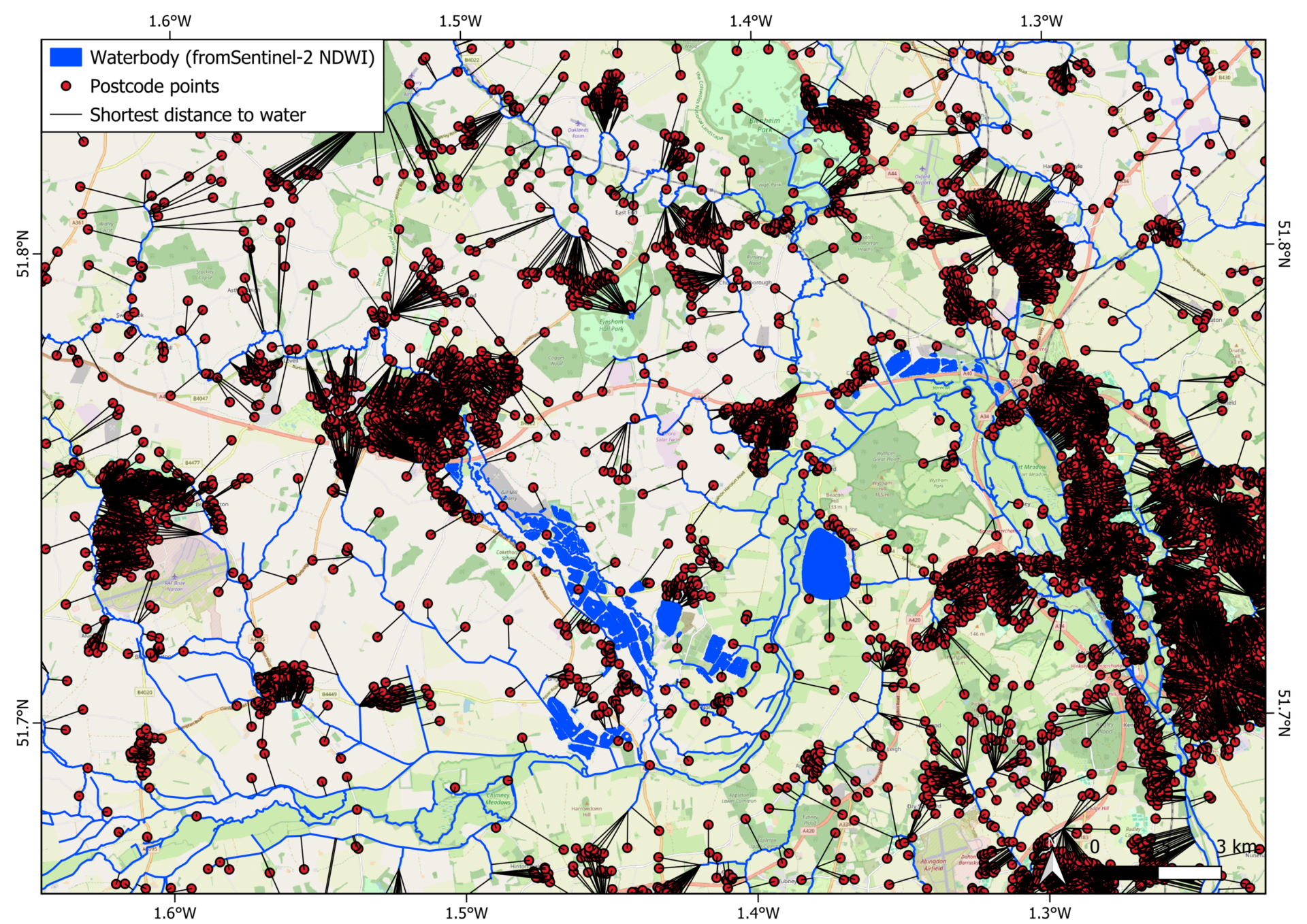
SHY, in collaboration with Go Compare, has piloted a project demonstrating how Earth observation data can enhance the insurance comparison market by assisting customers with home insurance queries. Using open-source Sentinel-2 imagery alongside the UK watercourse map, the project improves coverage of UK waterbodies.
By integrating free postcode data, GIS tools, and programming, a demo was developed to automatically calculate the shortest distance from a given postcode to the nearest waterbody. While highlighting the limitations of open-source geospatial data, the project shows that commercial datasets—such as detailed address information and tree distribution maps—can offer more precise insights for home insurance assessments. Click here to view the full report.
Barriers to Downstream Earth Observation Applications and Services and Impact of Interventions

SHY, in collaboration with Perspective Economics, is conducting a study into the barriers to downstream EO applications and services. The study consists of an in-depth analysis of the current state of the UK’s public and commercial EO market, an assessment of interventions by governments within the UK and abroad, and an extensive stakeholder engagement campaign via both online survey and live consultations.
The study, due to be completed in March 2025, will result in a report providing recommendations for addressing the barriers to EO adoption in the public and commercial sectors. The outputs will also include an in-depth cost-benefit analysis of potential future Government interventions.
EO Agri-Data Explorer App

EO data can be used to supplement ground measurements of farming activities, techniques, and aid in near real time assessments of, for example, crop and soil health, and water usage. However, it is not easy for an organisation that is new to using EO data to assess what data would be appropriate and whether the cost is worth the benefit for their organisation.
To allow organisations to independently assess the utility of EO data, GreenSpace has produced an app (EO Agri-Data Explorer) that allows a user to select a field within the UK and access time averaged or snapshot maps of agriculturally useful EO-derived indices and maps for free. The app uses Sentinel 2 data, processes it and clips the data to the boundaries of the field. The app is aimed as a learning and exploration tool, and the user guide refers users onwards to organisations and resources to further their exploration of EO data, broadening access. Click to access the app and user guide. The raw code can be accessed here.
Earth Observation Opportunities in Agricultural-Related Environmental Impact Reporting for the Financial Services Sector

SHY, in collaboration with Agtelligence, conducted a project to explore the potential for Earth Observation (EO) data to enhance climate-related reporting within financial institutions. The project involved a comprehensive analysis of the reporting requirements, both internal and external, of major financial institutions, as well as their long-term environmental monitoring and reporting goals.
Through desk-based research and one-on-one interviews, the project assessed the current use of EO data within the sector, identified opportunities for its future application, and highlighted the potential benefits for strengthening climate-related disclosures in line with the Task Force on Climate-Related Financial Disclosures (TCFD) framework. The findings were compiled into a report with actionable recommendations for optimally leveraging EO data to support financial institutions’ reporting needs.
Earth Observation Data Demonstrations for Local Climate Interests
The Yorkshire & Humber Climate Commission (YHCC) is an independent advisory body that brought together public, private, and third-sector organisations and individuals with the common goal of driving climate action in the Yorkshire and Humber region. Space Hub Yorkshire, through the GreenSpace project, developed proof-of-concept solutions based on satellite and geospatial data that could be used to support some of YHCC’s areas of interest and activity.
Three working demonstrations were produced:
– Remote detection of reintroduced beaver activity using free satellite data.
– Large-scale mapping of green vegetation to understand the region’s environment at scale and assess how climate change and regional interventions were affecting crops, forests, and grasslands.
– Large-scale coastline mapping to support long-term monitoring of coastal erosion.
Click here to view the full report.
Leveraging Earth Observation Imagery for Biodiversity Assessment in Food Production Systems
Typically, monitoring biodiversity on farmland is an expensive and labour-intensive activity. Agtelligence, a company focused on promoting sustainable agriculture practices through the use of Earth Observation (EO) technology, collaborated with Airbus Space and Defence to simplify this process. The GreenSpace team provided support to this Agtelligence-led project.
By combining AI and high-resolution satellite data, they aimed to streamline the monitoring of biodiversity. The project focused on assessing the quality of biodiverse habitats, particularly woody features, natural on-farm areas, and woodland patches, which are significant for UK farmland. These assessments were integrated into Agtelligence’s existing FarmScore® system, enhancing sustainability monitoring capabilities.